Severe Weather Outbreak Expected For Plains Friday
A severe weather outbreak, including the potential for strong tornadoes, is ramping up into Friday from Texas to parts of the Midwest, part of a multi-day siege of thunderstorms also with hail, damaging winds and flooding rain that could last into next week.
Almost on cue as March arrived, we’re setting up a stuck weather pattern that will bring multiple days in a row of at least some severe thunderstorms in the nation’s midsection through the middle of next week.
(MORE: Severe Weather Outbreak Maps Tracker)
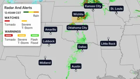
Several tornadoes were spotted in western and northwestern Oklahoma Thursday evening, including around Cleo Springs and Wakita, Oklahoma.
Here’s a look at the current radar and alerts:
Severe Threat Timing
Friday
Strong thunderstorms will likely be traversing the Central Plains with the threat of strong winds, large hail and a few tornadoes by around sunrise Friday.
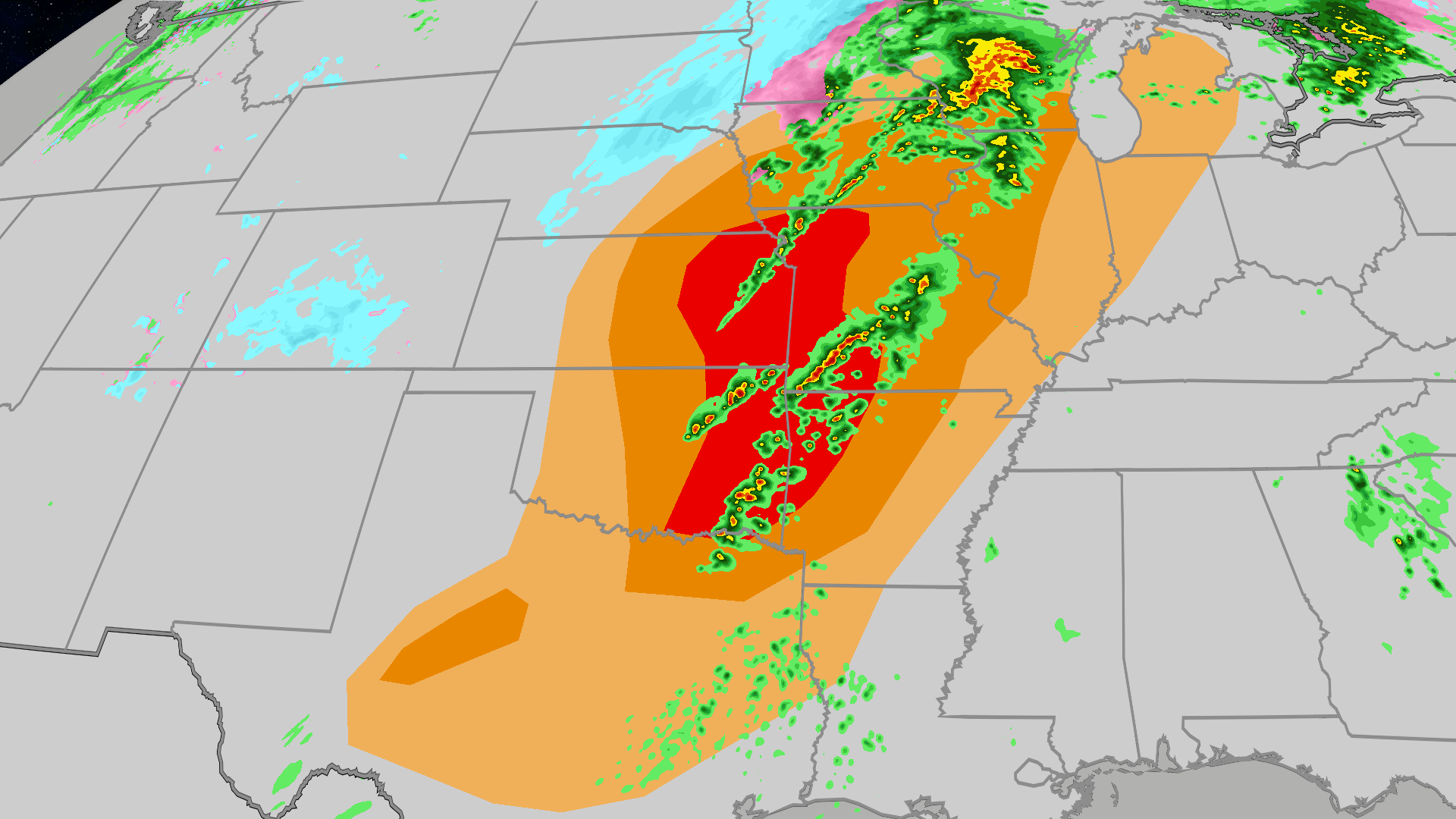
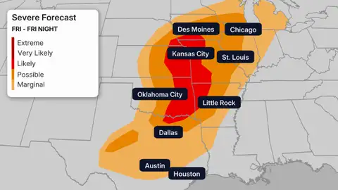
The rest of Friday appears to be a hospitable to a more widespread and more intense outbreak of severe thunderstorms from Texas to the upper Midwest.
NOAA’s Storm Prediction Center issued a level 3 severe weather threat in their outlook, with the potential for numerous supercell thunderstorms capable of strong tornadoes, defined as those of at least EF2 intensity from parts of northern Texas into southeast Nebraska and southern Iowa.
Large hail, possibly baseball size or larger, and destructive thunderstorm winds are also possible.
At least some severe thunderstorms with hail are possible as far north as southern Minnesota into the southern Great Lakes, including Chicagoland, Friday.
Cities: Austin, Dallas, Oklahoma City, Tulsa, Kansas City, Omaha, Des Moines, Chicago, Madison, St. Louis
(MORE: SPC Is Issuing New Intensity Forecasts | Classic Ingredients For An Outbreak)
(MORE: Beware Of March For Tornadoes, Especially Recently)
This Weekend And Beyond
The story doesn’t end there. Some strong to severe storms are possible Saturday from the Ohio Valley and Appalachians to eastern and central Texas.
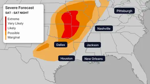
A few strong to severe storms are possible in parts of the South Sunday along and near a sagging and stalling frontal boundary.
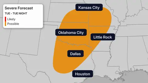
Additional strong to severe storms are expected early to mid-next week when a strong cold front slices into the central and eastern U.S. as a strong upper-level low-pressure system over northern Mexico finally gets kicked into the Plains.
NOAA’s Storm Prediction Center has already highlighted another threat of severe storms Tuesday, including some of the same areas that will be hit this week in the Plains.
(MAPS: 7-Day US Forecast)
Check back with us at weather.com and The Weather Channel app for updates to this forecast.
In the meantime, make sure you are prepared before severe weather threatens your area.
Have multiple ways of receiving official National Weather Service watches and warnings, including ways to wake you up at night. Know where the safest place is to take shelter where you live and do so immediately when receiving a warning.
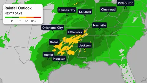
How Much Rain?
We’ve already seen flash flooding this week in parts of the Ohio Valley and Plains. Water rescues were needed on flooded roads on the south side of the Dallas metro Wednesday. At least several inches of water impacted some homes and businesses in Millville, Ohio, north of Cincinnati, Wednesday.
Dallas saw a daily rainfall record on Tuesday with 1.55 inches. This breaks the old record of 1.27 inches set back in 1937.
St. Louis also saw a daily rainfall record on Tuesday with 1.74 inches, breaking the old record of 1.5 inches et in 1935.
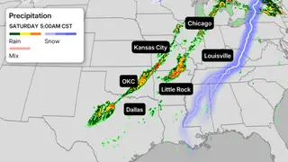
Locally heavy rainfall is likely with these multiple rounds of thunderstorms through the middle of next week. Some areas from the Southern Plains into the Mississippi and Ohio valleys may pick up an additional 3 inches or more of rain.
That could lead to additional flash flooding, particularly from the eastern half of Texas into eastern Oklahoma, Arkansas, northern Louisiana and northward into the Ohio Valley.
Soaking A Drought
These parts of the country are very much in need of rainfall. Drought persists across much of the South, and the reason is actually fairly straightforward.
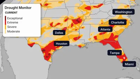
Current areas of drought as of Feb. 26, 2026.
(Data: US Drought Monitor)
We have been under a La Niña this winter, which causes some significant impacts to our weather.
(MORE: La Niña Is Fading)
A La Niña occurs when trade winds moving from east to west across the equator over the Pacific Ocean ramp up, pushing warm water to the Western Pacific. This forces cooler water to rise to the surface across the eastern region of the equatorial Pacific Ocean.
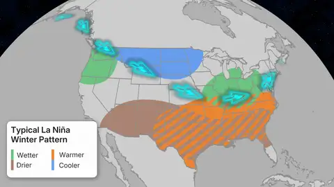
A typical La Niña Pattern
This simple change has a drastic impact on the weather around the world and is amplified in the winter.
In a typical La Niña winter, the jet stream is typically forced farther north, leaving the South warmer and drier. That pattern sends most of the precipitation and cooler temperatures to the north.
Rob Shackelford is a meteorologist and climate scientist at weather.com. He received his undergraduate and master’s degrees from the University of Georgia studying meteorology and experimenting with alternative hurricane forecasting tools.